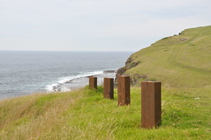
This section opened late in 2009 and takes a dramatic cliff top route between Kiama Heights and Werri Lagoon. The surroundings are rich in history and geological interest. There are signs along the walk that unravel some of the mysteries of the area. The full walking track extends north to Minnamurra and south as far as Gerringong's Boat Harbour.
This particular section - Loves Bay (Kiama) to Werri Lagoon (Gerringong) is a 12 kilometre walk (rated moderate) taking approximately 5 hours.
When the original land grants were made here in the 1800s, a strip of public land was set aside for access between private properties and the high water mark.
Unfortunately there were two properties where public land was not established. This omission blocked legal public access to this particular part of the shoreline for about 170 years!
In 2008, after Kiama Council successfully lobbied the State Government the connecting lands were acquired into the NSW Coastal Lands Protection Scheme. This has enabled legal and safe public access to this rugged stretch of coast.

No comments:
Post a Comment